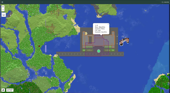
厌倦了 squaremap 上所有 Towny 领地都是同一种颜色、根本分不清谁是谁? 试试 SquareTowny —— 每个城镇都有专属颜色,同一国家的城镇同色,领土范围一眼就能看清。
Tired of every Towny claim looking the same on squaremap? Try SquareTowny — each town gets its own color, towns in the same nation share one, and territory becomes clear at a glance.
SquareTowny
English · 简体中文
SquareTowny is a Spigot plugin that works as an add-on to Towny. It renders the claim areas of every town onto a web map, so players can see the territory of each town (and nation) directly on the map.
This repository is a squaremap-oriented customized fork of TownyAdvanced/MapTowny (originally by Silverwolfg11, MIT licensed) with the following changes:
- Automatic distinct colors (new feature): every town is rendered with its own color, and towns in the same nation share the same color.
- Removed the
maptowny-pl3xmap-v2andmaptowny-pl3xmap-v3modules, because their build dependencies are no longer published on Modrinth's Maven repository and can no longer be resolved. - The remaining supported web maps are: squaremap, dynmap, BlueMap and Pl3xMap v1 (squaremap is the primary target).
Features
- Each town gets a visually distinct color (auto-generated). Towns belonging to the same nation share one color, so nation borders are easy to spot.
- Colors set manually in Towny (
/town set mapcolor,/nation set mapcolor) always take priority over auto-generated colors. - Configurable marker options: fill/stroke colors, opacity, stroke width, icons, etc.
- Fully async processing; the server thread is never blocked.
- Multiple web-map support: squaremap, dynmap, BlueMap (limited), Pl3xMap v1.
- Unit-tested polygon outline (contour) and negative-space (hole-finding) algorithms.
Supported Web Maps
| Map | Version | Support |
|---|---|---|
| squaremap | current | Full (primary) |
| dynmap | current | Full |
| BlueMap | v3.3+ | Limited |
| Pl3xMap v1 | v1 (use this fork for 1.18+) | Full |
Dependencies
- Towny 0.97.1 or later (required)
- One of the web-map plugins listed above (required)
Installation
- Put the plugin jar (
maptowny-plugin/target/SquareTowny-1.0.jar) into your server'spluginsfolder. - Restart the server. A
SquareTowny/config.ymlfile will be generated. - Set the
enabled-worldsoption to the worlds where you want town claims to show up.
Usage & Configuration
The plugin works out of the box. The most common adjustment is enabled-worlds.
Commands
| Command | Description | Permission |
|---|---|---|
/maptowny reload |
Reload the config and re-render all towns | maptowny.reload |
/maptowny render <town> |
Render a single town | maptowny.render |
/maptowny unrender <town or uuid> |
Remove a town from the map | maptowny.unrender |
All commands require maptowny.use (default: op). maptowny.admin grants all of the above.
Config options (config.yml)
| Option | Default | Description |
|---|---|---|
enabled-worlds |
["world"] |
Worlds where town claims are shown |
update-period |
5 |
Interval (minutes) at which all towns are re-rendered |
layer.* |
— | Layer name, visibility controls, priority, z-index |
fill-style.fill-color |
"#3388ff" |
Default fill color |
fill-style.fill-opacity |
0.2 |
Fill opacity |
fill-style.use-nation-color-fill |
true |
Use the nation's color to fill claims |
fill-style.stroke-color |
"#3388ff" |
Default stroke color |
fill-style.use-town-color-fill |
false |
Use the town's own color (takes priority over the nation color) |
fill-style.use-auto-colors |
true |
Auto colors (this fork): give every town/nation a distinct color |
icon-info.* |
— | Town / capital / outpost icon images and sizes |
How auto colors work
- A town without a nation gets a unique color derived from its UUID (stable across restarts).
- All towns in the same nation share the same color, derived from the nation's UUID.
- If a color was manually set in Towny for the town or its nation, the manual color is used instead.
- Colors update automatically on the next periodic re-render (or with
/maptowny reload).
Plugin API
SquareTowny exposes a small API (maptowny-api module) to let other plugins integrate. See the original project's wiki for details.
Building
This is a standard Maven multi-module project that uses the maven-toolchains-plugin. The modules are compiled for different JDK versions:
| Module | JDK target |
|---|---|
maptowny-api, maptowny-plugin, maptowny-dynmap |
8 |
maptowny-bluemap |
11 |
maptowny-squaremap, maptowny-pl3xmap-v1 |
16 |
Two ways to build:
-
Standard toolchains — configure a
~/.m2/toolchains.xmlwith JDK 8, 11 and 16 (see the toolchains guide), then runmvn clean package. -
Single modern JDK (included) — this repository ships a
toolchains-local.xmlthat maps every required version to one JDK (21 or newer). Edit thejdkHomepath to point at your JDK, then run:mvn -t toolchains-local.xml clean package
The finished plugin jar is maptowny-plugin/target/SquareTowny-1.0.jar.
License
MIT. This fork retains the original MIT license and copyright of the upstream project. Pull requests are welcome.
简体中文
厌倦了 squaremap 上所有 Towny 领地都是同一种颜色、根本分不清谁是谁? 试试 SquareTowny —— 每个城镇都有专属颜色,同一国家的城镇同色,领土范围一眼就能看清。
项目简介
SquareTowny 是一个基于 Spigot 的插件,作为 Towny 的扩展,把每个城镇的领地范围渲染到网页地图上,玩家可以直接在地图上看到各个城镇(以及国家)的领土。
本仓库是 TownyAdvanced/MapTowny(原作者 Silverwolfg11,MIT 协议)的面向 squaremap 的定制分支,主要改动如下:
- 自动配色(新增功能):每个城镇在地图上显示不同的颜色,同一国家的城镇颜色相同。
- 移除了
maptowny-pl3xmap-v2和maptowny-pl3xmap-v3模块——这两个模块的构建依赖已从 Modrinth 的 Maven 仓库下架,无法再解析。 - 目前支持的地图插件为:squaremap、dynmap、BlueMap 和 Pl3xMap v1(squaremap 为主要目标)。
功能特性
- 每个城镇自动生成独一无二的颜色;同一国家内的城镇共用同一种颜色,国家边界一目了然。
- Towny 中手动设置的颜色(
/town set mapcolor、/nation set mapcolor)始终优先于自动颜色。 - 可配置的标记样式:填充/描边颜色、透明度、描边粗细、图标等。
- 全异步处理,不阻塞主线程。
- 同时支持多种网页地图:squaremap、dynmap、BlueMap(支持有限)、Pl3xMap v1。
- 附带单元测试的多边形轮廓算法与负空间("找洞")算法。
支持的地图插件
| 地图 | 版本 | 支持程度 |
|---|---|---|
| squaremap | 最新 | 完整(主要目标) |
| dynmap | 最新 | 完整 |
| BlueMap | v3.3+ | 有限 |
| Pl3xMap v1 | v1(1.18+ 请用这个分支) | 完整 |
依赖
- Towny 0.97.1 及以上(必需)
- 上表中的一个网页地图插件(必需)
安装
- 把插件 jar(
maptowny-plugin/target/SquareTowny-1.0.jar)放入服务器的plugins目录。 - 重启服务器,会自动生成
SquareTowny/config.yml。 - 把
enabled-worlds改成你想显示领地范围的世界名。
使用与配置
开箱即用,最常需要调整的是 enabled-worlds。
命令
| 命令 | 说明 | 权限 |
|---|---|---|
/maptowny reload |
重载配置并重新渲染所有城镇 | maptowny.reload |
/maptowny render <城镇名> |
渲染指定城镇 | maptowny.render |
/maptowny unrender <城镇名或UUID> |
从地图上移除指定城镇 | maptowny.unrender |
所有命令都需要 maptowny.use(默认 op);maptowny.admin 包含以上所有权限。
配置项(config.yml)
| 配置项 | 默认值 | 说明 |
|---|---|---|
enabled-worlds |
["world"] |
显示领地范围的世界 |
update-period |
5 |
全量重渲染周期(分钟) |
layer.* |
— | 图层名称、显示开关、优先级、z-index |
fill-style.fill-color |
"#3388ff" |
默认填充色 |
fill-style.fill-opacity |
0.2 |
填充不透明度 |
fill-style.use-nation-color-fill |
true |
用国家颜色填充领地 |
fill-style.stroke-color |
"#3388ff" |
默认描边色 |
fill-style.use-town-color-fill |
false |
用城镇自己的颜色(优先于国家色) |
fill-style.use-auto-colors |
true |
自动配色(本分支新增):让每个城镇/国家颜色各不相同 |
icon-info.* |
— | 城镇/首都/前哨站图标及尺寸 |
自动配色说明
- 没有国家的城镇:按城镇 UUID 生成独一无二的颜色(重启后保持稳定)。
- 同一国家内的城镇:共用同一种颜色(按国家 UUID 生成)。
- 城镇或国家在 Towny 中手动设置过颜色时,使用手动颜色。
- 颜色会在下一次周期重渲染时自动更新(或执行
/maptowny reload)。
插件 API
SquareTowny 提供小型 API(maptowny-api 模块)供其他插件集成,详见原项目的 Wiki。
构建
这是一个标准 Maven 多模块项目,使用 maven-toolchains-plugin 针对不同 JDK 版本编译各模块:
| 模块 | JDK 目标 |
|---|---|
maptowny-api、maptowny-plugin、maptowny-dynmap |
8 |
maptowny-bluemap |
11 |
maptowny-squaremap、maptowny-pl3xmap-v1 |
16 |
两种构建方式:
-
标准 toolchains:在
~/.m2/toolchains.xml中配置 JDK 8、11、16(参考 toolchains 指南),然后执行mvn clean package。 -
单一现代 JDK(仓库自带配置):本仓库附带了
toolchains-local.xml,把所有需要的版本映射到同一个 JDK(21 或更新)。把其中jdkHome改成你本机的 JDK 路径后执行:mvn -t toolchains-local.xml clean package
构建产物为 maptowny-plugin/target/SquareTowny-1.0.jar。
许可证
MIT。本分支保留上游项目的 MIT 许可证与版权声明,欢迎提交 Pull Request。